Round Rock topographic map
Click on the map to display elevation.
Round Rock
The city straddles the Balcones Escarpment, a fault line in which the areas roughly east of I-35 are flat and characterized by having black, fertile soils of the Blackland Prairie, and the west side of the Escarpment, which consists mostly of hilly, karst-like terrain with little topsoil and higher elevations and which is part of the Texas Hill Country. Located about 20 miles (32 km) north of Austin, Round Rock shares a common border with Austin near State Highway 45.
About this map
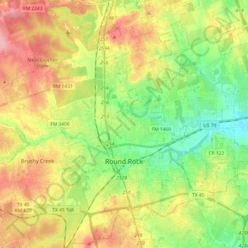
Name: Round Rock topographic map, elevation, terrain.
Location: Round Rock, Williamson County, Texas, United States (30.46829 -97.76484 30.59378 -97.59005)
Average elevation: 242 m
Minimum elevation: 191 m
Maximum elevation: 306 m
Other topographic maps
Click on a map to view its topography, its elevation and its terrain.

Georgetown
United States > Texas > Williamson County > Georgetown
The city is located on the northeastern edge of Texas Hill Country. Portions of Georgetown are located on either side of the Balcones Escarpment, a fault line in which the areas roughly east of IH-35 are flat and characterized by having black, fertile soils of the Blackland Prairie, and the west side of the…
Average elevation: 228 m
Soil Conservation Service Site 12 Dam
United States > Texas > Williamson County > Type
Average elevation: 173 m
Soil Conservation Service Site 12 Dam
United States > Texas > Williamson County > Type
Average elevation: 173 m
Soil Conservation Service Site 12 Dam
United States > Texas > Williamson County > Type
Average elevation: 173 m