
Castile and León topographic map
Interactive map
Click on the map to display elevation.
Castile and León
The morphology of Castile and León consists, for the most part, of the northern half of the Meseta Central (Meseta Norte) and a belt of mountainous reliefs. The Meseta Central is a high plateau with an average altitude close to 800 m (2,600 ft) above sea-level; it is covered by deposited clay materials that have given rise to a dry and arid landscape.
About this map
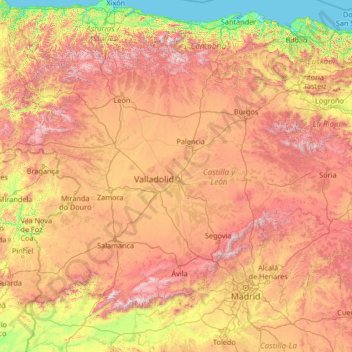
Name: Castile and León topographic map, elevation, terrain.
Location: Castile and León, Spain (40.08245 -7.07707 43.23820 -1.77537)
Average elevation: 770 m
Minimum elevation: -1 m
Maximum elevation: 2,468 m
Other topographic maps
Click on a map to view its topography, its elevation and its terrain.
Santiago de Compostela
Spain > Galicia > Santiago de Compostela
The cathedral borders the main plaza of the old and well-preserved city. According to medieval legend, the remains of the apostle James were brought to Galicia for burial; in 813, the light of a bright star guided a shepherd who was watching his flock at night to the burial site in Santiago de Compostela. This…
Average elevation: 248 m
Las Rozas / Les Roces
Spain > Cangas de Onís > Cangas de Onís / Cangues d'Onís > Las Rozas / Les Roces
Average elevation: 155 m