Geolocate

Borneo topographic map

Click on the map to display elevation.

Borneo

Before sea levels rose at the end of the last Ice Age, Borneo was part of the mainland of Asia, forming, with Java and Sumatra, the upland regions of a peninsula that extended east from present day Indochina. The South China Sea and Gulf of Thailand now submerge the former low-lying areas of the peninsula. Deeper waters separating Borneo from neighbouring Sulawesi prevented a land connection to that island, creating the divide known as Wallace's Line between Asian and Australia-New Guinea biological regions. The island today is surrounded by the South China Sea to the north and northwest, the Sulu Sea to the northeast, the Celebes Sea and the Makassar Strait to the east, and the Java Sea and Karimata Strait to the south. To the west of Borneo are the Malay Peninsula and Sumatra. To the south and east are islands of Indonesia: Java and Sulawesi, respectively. To the northeast are the Philippine Islands. With an area of 743,330 square kilometres (287,000 sq mi), it is the third-largest island in the world, and is the largest island of Asia (the largest continent). Its highest point is Mount Kinabalu in Sabah, Malaysia, with an elevation of 4,095 m (13,435 ft).

Wikipedia (CC-BY-SA 3.0)

About this map

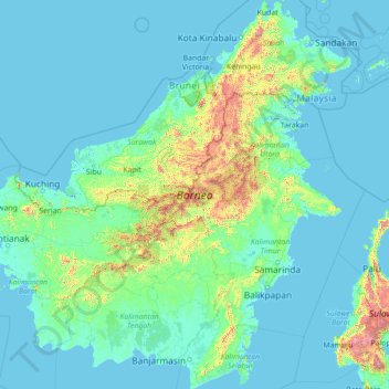
Name: Borneo topographic map, elevation, terrain.

Location: Borneo, Kalimantan, Indonesia (-4.17791 108.83747 7.03748 119.26689)

Average elevation: 141 m

Minimum elevation: -4 m

Maximum elevation: 3,808 m

Other topographic maps

Click on a map to view its topography, its elevation and its terrain.

Buntu Sinaji

Indonesia > South Sulawesi

Average elevation: 2,130 m

Bukit Telaga

Indonesia > West Kalimantan > Kapuas Hulu

Average elevation: 51 m

Bukit Besai

Indonesia > West Kalimantan > Kapuas Hulu

Average elevation: 482 m

Salakaria

Indonesia > West Java > Ciamis

Average elevation: 193 m

Senggi

Indonesia > Papua > Keerom

Average elevation: 259 m

Upt Arso Vi / Yamua

Indonesia > Papua > Keerom

Average elevation: 45 m

Bahenap

Indonesia > West Kalimantan > Kapuas Hulu

Average elevation: 223 m

Batee

Indonesia > Aceh > Pidie

Average elevation: 13 m

Sukalaksana

Indonesia > West Java > West Bandung > Lembang

Average elevation: 1,288 m

Songgokerto

Indonesia > Batu

Average elevation: 1,029 m

Tlekung

Indonesia > East Java > Batu

Average elevation: 968 m

Pangea

Indonesia > Gorontalo > Gorontalo

Average elevation: 52 m

Gayamprit

Indonesia > Central Java > Klaten

Average elevation: 170 m

Gandasari

Indonesia > West Java

Average elevation: 23 m

Cikole

Indonesia > West Java > Kabupaten Bandung

Average elevation: 1,722 m

Tumiyang

Indonesia > Central Java > Banyumas

Average elevation: 324 m

Argomulyo

Indonesia > Central Java > Salatiga

Average elevation: 675 m

Bongsari

Indonesia > Central Java > Semarang

Average elevation: 26 m

Banjarsari

Indonesia > Kabupaten Bandung

Average elevation: 1,520 m

Temas

Indonesia > East Java > Batu

Average elevation: 855 m

Gudangkahuripan

Indonesia > West Java > West Bandung

Average elevation: 1,121 m

Limboto

Indonesia > Gorontalo > Gorontalo

Average elevation: 32 m

Rinjani

Indonesia > West Nusa Tenggara

In September 1995 an aviation report was issued concerning an unconfirmed ash cloud from Rinjani. A NOTAM about volcanic activity from Rinjani was issued by the Bali Flight Information Region on the morning of 12 September. An ash cloud was reportedly drifting to the south west with the cloud top around 4 km…

Average elevation: 3,071 m

Cihideung

Indonesia > West Java > West Bandung

Average elevation: 1,259 m

Wahoo Waterworld

Indonesia > West Bandung > Jayamekar

Average elevation: 680 m

Go! Wet Waterpark

Indonesia > West Java > Bekasi

Average elevation: 30 m

Buntu Tambolang

Indonesia > South Sulawesi

Average elevation: 1,354 m

Bokor

Indonesia > Riau > Kepulauan Meranti

Average elevation: 3 m

Semar

Indonesia > Central Java > Tlogowungu

Average elevation: 296 m

Asei Kecil

Indonesia > Papua > Jayapura

Average elevation: 140 m

Aeknabara

Indonesia > North Sumatra > Mandailing Natal

Average elevation: 422 m

Sumillan

Indonesia > South Sulawesi > Enrekang

Average elevation: 955 m

Pekkabata

Indonesia > South Sulawesi > Pinrang

Average elevation: 9 m

Kebun Bunga

Indonesia > South Sumatra > Palembang

Average elevation: 11 m

Sidokumpul

Indonesia > East Java > Sidoarjo > Sidoarjo

Average elevation: 4 m

Jemah

Indonesia > West Java > Sumedang

Average elevation: 279 m

Pagerwangi

Indonesia > West Java > West Bandung

Average elevation: 1,173 m

Puncak Jaya

Indonesia > Central Papua > Mimika

Puncak Jaya (Indonesian: [ˈpuntʃak ˈdʒaja]; literally "Victorious Peak", Amungme: Nemangkawi Ninggok) or Carstensz Pyramid (/ˈkɑːrstəns/, Indonesian: Piramida Carstensz, Dutch: Carstenszpiramide) on the island of New Guinea, with an elevation of 4,884 m (16,024 ft), is the highest mountain peak of an…

Average elevation: 4,271 m

Perawang

Indonesia > Riau > Siak

Average elevation: 10 m

Belimbing

Indonesia > East Kalimantan > Bontang

Average elevation: 20 m

Situ Cibeureum

Indonesia > West Java > Rawa Banteng

Average elevation: 31 m

Batugaing

Indonesia > Bali > Kediri > Beraban

Average elevation: 23 m

Kraton

Indonesia > East Java > Sidoarjo

Average elevation: 13 m

Beji

Indonesia > East Java > Batu

Average elevation: 790 m

Dusun 1

Indonesia > Central Sulawesi > Desa Jono Oge

Average elevation: 76 m

Kenteng

Indonesia > Central Java > Salatiga > Tegalrejo

Average elevation: 650 m

Kemirirejo

Indonesia > Central Java > Magelang

Average elevation: 360 m

Darmaraja

Indonesia > Sumedang

Average elevation: 350 m

Purana

Indonesia > Central Java > Pemalang

Average elevation: 68 m

Alun-Alun Batu

Indonesia > East Java > Batu > Temas

Average elevation: 892 m

Oro-oro Ombo

Indonesia > Batu

Average elevation: 952 m

Bangunsari

Indonesia > West Java > Purwakarta

Average elevation: 76 m

Ketajen

Indonesia > East Java > Sidoarjo

Average elevation: 4 m

Kaligawe Selatan

Indonesia > Central Java > Klaten > Kaligawe

Average elevation: 109 m

Jimbaran

Indonesia > Bali > Badung > Jimbaran

Average elevation: 9 m

Mount Bromo

Indonesia

Average elevation: 2,239 m

Gumuksari

Indonesia > Central Java > Kabupaten Semarang > Lopait

Average elevation: 501 m

Cibodas

Indonesia > West Java > West Bandung > Lembang

Average elevation: 1,263 m

Mekarwangi

Indonesia > West Java > West Bandung

Average elevation: 1,331 m

Gunung Perigi

Indonesia > West Nusa Tenggara

Average elevation: 1,336 m

Karangploso

Indonesia > Kabupaten Malang

Average elevation: 648 m

Pandawa Beach

Indonesia > Bali > Kuta Selatan > Kutuh

Average elevation: 46 m

Baloi

Indonesia > Riau Islands > Batam

Average elevation: 24 m

Kersan, Kebondalem

Indonesia > Central Java > Kendal > Malang

Average elevation: 5 m

Pulau Limau

Indonesia > Lampung > Tanggamus

Average elevation: 59 m

Asahmunduk

Indonesia > Bali > Banjar > Munduk

Average elevation: 1,236 m

Desa Borobudur

Indonesia > Central Java > Magelang

Average elevation: 251 m

Sukadamai

Indonesia > Aceh > Bener Meriah

Average elevation: 1,095 m

Weru Lor

Indonesia > West Java > Cirebon

Average elevation: 15 m

Jatiarjo

Indonesia > East Java > Pasuruan

Average elevation: 725 m

Jebres

Indonesia > Central Java > Surakarta

Average elevation: 100 m

Gunung Lesung

Indonesia > Central Java > Pekalongan > Windurojo

Average elevation: 147 m

Dampyak

Indonesia > Central Java > Batang > Gemuh

Average elevation: 472 m

Bekasi

Indonesia > West Java

The City of Bekasi is a part of the Bekasi river basin, located in the downstream area of the basin with slopes ranging from 0 to 2% and elevations between 11 meters to 81 meters above sea level. The city of Bekasi is part of the Bekasi river basin and is located in the downstream area of the basin, with a…

Average elevation: 23 m

Muarasoma

Indonesia > North Sumatra > Mandailing Natal

Average elevation: 259 m

Kebun Raya ITERA

Indonesia > Lampung > Lampung Selatan > Way Huwi

Average elevation: 102 m

Kapar

Indonesia > South Kalimantan > Hulu Sungai Tengah

Average elevation: 18 m