
Portsmouth topographic map
Interactive map
Click on the map to display elevation.
About this map
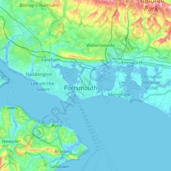
Name: Portsmouth topographic map, elevation, terrain.
Location: Portsmouth, South East, England, PO1 5QH, United Kingdom (50.64368 -1.23561 50.96368 -0.91561)
Average elevation: 28 m
Minimum elevation: -5 m
Maximum elevation: 236 m
Other topographic maps
Click on a map to view its topography, its elevation and its terrain.
Spider Lake
United Kingdom > England > Portsmouth
Spider Lake, Portsmouth, South East England, England, PO16 9NQ, United Kingdom
Average elevation: 1 m