
Thank you for supporting this site ❤️
Make a donation
Make a donation
Beqaa Governorate topographic map
Click on the map to display elevation.
Thank you for supporting this site ❤️
Make a donation
Make a donation
About this map
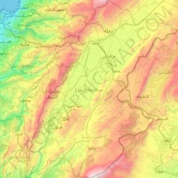
Name: Beqaa Governorate topographic map, elevation, terrain.
Location: Beqaa Governorate, Lebanon (33.41111 35.60756 33.93669 36.13097)
Average elevation: 1,106 m
Minimum elevation: 0 m
Maximum elevation: 2,808 m
Thank you for supporting this site ❤️
Make a donation
Make a donation
Other topographic maps
Click on a map to view its topography, its elevation and its terrain.
Zahle
Zahlé is located 55 km (34 mi) east of the capital Beirut, close to the Beirut-Damascus road, and lies at the junction of the Lebanon mountains and the Beqaa plateau, at a mean elevation of 1,000 m. Zahlé is known as the "Bride of the Beqaa" and "the Neighbor of the Gorge" for its geographical location and…
Average elevation: 1,281 m
Thank you for supporting this site ❤️
Make a donation
Make a donation