
Make a donation
Provincia di Imperia topographic map
Click on the map to display elevation.
Make a donation
About this map
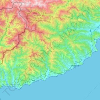
Name: Provincia di Imperia topographic map, elevation, terrain.
Location: Provincia di Imperia, Liguria, Italy (43.77569 7.49516 44.14102 8.13540)
Average elevation: 604 m
Minimum elevation: 0 m
Maximum elevation: 2,636 m
Make a donation
Other topographic maps
Click on a map to view its topography, its elevation and its terrain.
Make a donation
Caverna delle Arene Candide
Italy > Liguria > Savona > Finale Ligure > Finalborgo
Average elevation: 69 m
Make a donation
Make a donation
Make a donation
Make a donation
Make a donation
Make a donation
Make a donation
Make a donation
Make a donation
Make a donation
Make a donation
Make a donation
Make a donation
Make a donation
Make a donation
Make a donation
Make a donation
La Spezia
Because of its topography, the city is not exposed to winds from the north, which lap western Liguria, but to those from the southeast. These may bring heavy rain and they can reach 80 kilometres per hour (50 mph), in rare cases causing the blocking of the port. The only northern wind reaching the city is the…
Average elevation: 35 m
Make a donation
Make a donation
I Palanchi
Italy > Liguria > Imperia > Ventimiglia > Torri Inferiore > Torri Superiore
Average elevation: 305 m