
Make a donation
Lexington County topographic map
Click on the map to display elevation.
Make a donation
Lexington County
According to the U.S. Census Bureau, the county has a total area of 757.62 square miles (1,962.2 km2), of which 699.00 square miles (1,810.4 km2) is land and 58.62 square miles (151.8 km2) (7.74%) is water. The largest body of water is Lake Murray, while other waterways include the Broad River, the Saluda River and the Congaree River. Lexington County has urban, suburban, and rural landscapes. Much of the county's urbanization is in its eastern and northeastern areas. The elevation in the county is 392 feet (119 m).
Make a donation
About this map
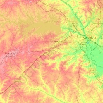
Name: Lexington County topographic map, elevation, terrain.
Location: Lexington County, South Carolina, United States (33.65294 -81.57131 34.19759 -80.92526)
Average elevation: 116 m
Minimum elevation: 28 m
Maximum elevation: 240 m
Make a donation
Other topographic maps
Click on a map to view its topography, its elevation and its terrain.
Make a donation
Make a donation
Make a donation
Make a donation
Little Table Rock Mountain
United States > South Carolina > Greenville County
Average elevation: 892 m
Mount Vernon Estates
United States > South Carolina > Greenville County > Greer
Average elevation: 302 m
Make a donation
Make a donation
Florence Soccer Complex
United States > South Carolina > Florence County > Florence
Average elevation: 42 m
North Charleston Wannamaker County Park
United States > South Carolina > Charleston County > North Charleston
Average elevation: 8 m
Make a donation
Woodland Trailer Park
United States > South Carolina > Oconee County > Walhalla
Average elevation: 303 m
Make a donation
Saint Andrews Heights
United States > South Carolina > Charleston County > Charleston
Average elevation: 5 m
Make a donation
Make a donation
Hilton Head Island
United States > South Carolina > Beaufort County > Hilton Head Island
Average elevation: 2 m
Make a donation
Make a donation
Make a donation
Make a donation
Make a donation
Royal Pines Country Club Estates
United States > South Carolina > Beaufort County
Average elevation: 7 m
Huntington Beach
United States > South Carolina > Georgetown County > North Litchfield Beach
Average elevation: 0 m
Make a donation
Make a donation
Make a donation
Make a donation
South Carolina Noname 12005 D-0209 Dam
United States > South Carolina > Chester County > Mountain Lakes
Average elevation: 149 m
Make a donation
Leesville
United States > South Carolina > Lexington County > Batesburg-Leesville
Average elevation: 190 m
Make a donation
Sassafras Mountain
United States > South Carolina > Pickens County
The Pisgah Quadrangle topographical map, revised 1904–1905, shows the long abandoned Sassafras Gap Road to be the preferred route through to Rosman, N.C. and Brevard, N.C. at the end of the 19th century and that the existing Highway 178 was then a secondary road. This abandoned road is a short distance from…
Average elevation: 895 m
Evergreen Place
United States > South Carolina > Greenville County > Greenville
Average elevation: 288 m
Make a donation
Battle of Camden National Historic Landmark
United States > South Carolina > Kershaw County > Flat Rock
Average elevation: 104 m
Make a donation
Make a donation
Naval Nuclear Power Training Command
United States > South Carolina > Berkeley County > Goose Creek
Average elevation: 5 m
Make a donation