
Thank you for supporting this site ❤️
Make a donation
Make a donation
Bischofsgrün topographic map
Click on the map to display elevation.
Thank you for supporting this site ❤️
Make a donation
Make a donation
About this map
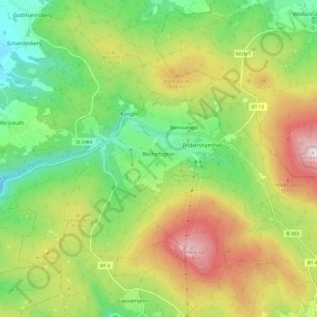
Name: Bischofsgrün topographic map, elevation, terrain.
Location: Bischofsgrün, Landkreis Bayreuth, Bavaria, 95493, Germany (50.03591 11.72738 50.06616 11.84109)
Average elevation: 744 m
Minimum elevation: 536 m
Maximum elevation: 1,036 m
Thank you for supporting this site ❤️
Make a donation
Make a donation
Other topographic maps
Click on a map to view its topography, its elevation and its terrain.
Bad Berneck
Germany > Bavaria > Landkreis Bayreuth > Bad Berneck im Fichtelgebirge
Average elevation: 474 m
Thank you for supporting this site ❤️
Make a donation
Make a donation
Thank you for supporting this site ❤️
Make a donation
Make a donation