
Thank you for supporting this site ❤️
Make a donation
Make a donation
Sarasota County topographic map
Click on the map to display elevation.
Thank you for supporting this site ❤️
Make a donation
Make a donation
About this map
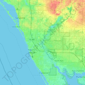
Name: Sarasota County topographic map, elevation, terrain.
Location: Sarasota County, Florida, United States (26.94536 -82.70544 27.38979 -82.05669)
Average elevation: 7 m
Minimum elevation: -2 m
Maximum elevation: 34 m
Thank you for supporting this site ❤️
Make a donation
Make a donation
Other topographic maps
Click on a map to view its topography, its elevation and its terrain.