
Make a donation
Federal District topographic map
Click on the map to display elevation.
Make a donation
Federal District
From the first republican constitution there was already a device that foresaw the move of the federal capital from Rio de Janeiro, at that time in the former Federal District (1889-1960), to the interior of the country. In 1891 the Exploration Commission of the Central Highlands of Brazil was appointed, led by astronomer Luiz Cruls and composed of doctors, geologists and botanists, who made a study on topography, climate, geology, flora, fauna and other material resources of the region of the Central Highlands The area was known as Quadrilateral Cruls and was presented in 1894 to the Republican Government.
Make a donation
About this map
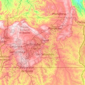
Name: Federal District topographic map, elevation, terrain.
Location: Federal District, Central-West Region, Brazil (-16.05056 -48.28579 -15.50018 -47.30839)
Average elevation: 983 m
Minimum elevation: 584 m
Maximum elevation: 1,349 m
Make a donation
Other topographic maps
Click on a map to view its topography, its elevation and its terrain.
Brasília
Brazil > Federal District > Região Integrada de Desenvolvimento do Distrito Federal e Entorno
The city sits at an elevation of 1,000 metres (3,300 ft) and more, high on the Brazilian Highlands in the country's center-western region. Paranoá Lake, a large artificial lake, was built to increase the amount of water available and to maintain the region's humidity. It has a marina, and hosts wakeboarders…
Average elevation: 1,084 m
Sugarloaf
Brazil > Rio de Janeiro > Região Metropolitana do Rio de Janeiro > Rio de Janeiro
Average elevation: 17 m
Make a donation
Make a donation
Pelotas
Brazil > Rio Grande do Sul > Aglomeração Urbana do Sul > Pelotas
As it is situated on a plain near the ocean, the urban area lies on a low elevation, being, on average, 7 meters (23 ft) above sea level. The interior of the municipality is on a plateau called Serras de Sudeste (Southeastern Mountain Ranges). Consequently, the altitude in Pelotas' rural area reaches 429…
Average elevation: 18 m
Make a donation
Make a donation
Petrópolis
Brazil > Rio de Janeiro > Região Metropolitana do Rio de Janeiro > Petrópolis
Average elevation: 683 m
Ilha do Búzio
Brazil > Pernambuco > Região Metropolitana do Recife > Ilha de Itamaracá
Average elevation: 7 m
Make a donation