
Thank you for supporting this site ❤️
Make a donation
Make a donation
Tondela topographic map
Click on the map to display elevation.
Thank you for supporting this site ❤️
Make a donation
Make a donation
About this map
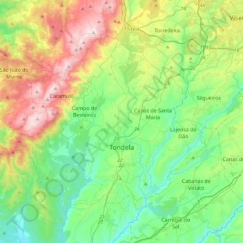
Name: Tondela topographic map, elevation, terrain.
Location: Tondela, Viseu, Portugal (40.44796 -8.30842 40.64067 -7.95915)
Average elevation: 399 m
Minimum elevation: 105 m
Maximum elevation: 1,052 m
Thank you for supporting this site ❤️
Make a donation
Make a donation