
Thank you for supporting this site ❤️
Make a donation
Make a donation
Sinai Peninsula topographic map
Click on the map to display elevation.
Thank you for supporting this site ❤️
Make a donation
Make a donation
Sinai Peninsula
Sinai is one of the coldest provinces in Egypt because of its high altitudes and mountainous topographies. Winter temperatures in some of Sinai's cities and towns reach −16 °C (3 °F).
Thank you for supporting this site ❤️
Make a donation
Make a donation
About this map
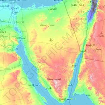
Name: Sinai Peninsula topographic map, elevation, terrain.
Location: Sinai Peninsula, Egypt (27.72414 32.31018 31.32333 34.90369)
Average elevation: 457 m
Minimum elevation: -415 m
Maximum elevation: 2,521 m
Thank you for supporting this site ❤️
Make a donation
Make a donation
Other topographic maps
Click on a map to view its topography, its elevation and its terrain.