
Thank you for supporting this site ❤️
Make a donation
Make a donation
Bengaluru topographic map
Click on the map to display elevation.
Thank you for supporting this site ❤️
Make a donation
Make a donation
Bengaluru
Bangalore (/bæŋɡəˈlɔːr/), officially known as Bengaluru (Kannada pronunciation: (listen)), is the capital and the largest city of the Indian state of Karnataka. It has a population of more than 8 million and a metropolitan population of around 11 million, making it the third most populous city and fifth most populous urban agglomeration in India. Located in southern India on the Deccan Plateau, at a height of over 900 m (3,000 ft) above sea level, Bangalore is known for its pleasant climate throughout the year. Its elevation is the highest among the major cities of India.
Thank you for supporting this site ❤️
Make a donation
Make a donation
About this map
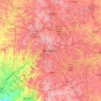
Name: Bengaluru topographic map, elevation, terrain.
Average elevation: 879 m
Minimum elevation: 712 m
Maximum elevation: 968 m
Thank you for supporting this site ❤️
Make a donation
Make a donation