
Thank you for supporting this site ❤️
Make a donation
Make a donation
Plech topographic map
Click on the map to display elevation.
Thank you for supporting this site ❤️
Make a donation
Make a donation
About this map
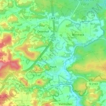
Name: Plech topographic map, elevation, terrain.
Average elevation: 475 m
Minimum elevation: 426 m
Maximum elevation: 567 m
Thank you for supporting this site ❤️
Make a donation
Make a donation
Other topographic maps
Click on a map to view its topography, its elevation and its terrain.
Bad Berneck
Germany > Bavaria > Landkreis Bayreuth > Bad Berneck im Fichtelgebirge
Average elevation: 474 m
Thank you for supporting this site ❤️
Make a donation
Make a donation
Thank you for supporting this site ❤️
Make a donation
Make a donation