
Make a donation
Humphreys County topographic map
Click on the map to display elevation.
Make a donation
About this map
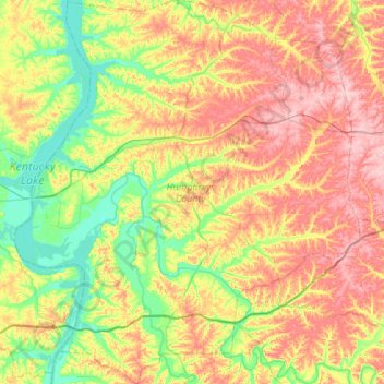
Name: Humphreys County topographic map, elevation, terrain.
Location: Humphreys County, Middle Tennessee, Tennessee, United States (35.80380 -88.02264 36.24475 -87.52979)
Average elevation: 174 m
Minimum elevation: 104 m
Maximum elevation: 268 m
Make a donation
Other topographic maps
Click on a map to view its topography, its elevation and its terrain.
Make a donation
Make a donation
Roan Mountain State Park
United States > Tennessee > Carter County > Roan Mountain
Roan Mountain State Park hosts a variety of outdoor activities including hiking, mountain biking, camping, cross-country skiing (during snowy, winter months), fishing, and swimming. A heated swimming pool is open from Memorial Day to mid-August. At an elevation of 2,972 feet (906 m), the outdoor swimming pool…
Average elevation: 988 m
Make a donation
Make a donation
Make a donation
Make a donation
Make a donation
Make a donation
Make a donation
Make a donation
Make a donation
Make a donation
Make a donation
Make a donation
Make a donation
Barfield Crescent Park
United States > Tennessee > Rutherford County > Murfreesboro
Average elevation: 201 m
Make a donation
Make a donation
Brainerd
United States > Tennessee > Hamilton County > Chattanooga > Ridgeside
Average elevation: 234 m
Make a donation
Millersville City Park
United States > Tennessee > Robertson County > Millersville
Average elevation: 260 m
Make a donation
Make a donation
Make a donation
Make a donation
Grassland Addition
United States > Tennessee > Cumberland County > Crossville
Average elevation: 560 m
Make a donation
Make a donation
Shepherd Forest
United States > Tennessee > Hamilton County > Signal Mountain
Average elevation: 459 m
Make a donation