
Thank you for supporting this site ❤️
Make a donation
Make a donation
Ulmen topographic map
Click on the map to display elevation.
Thank you for supporting this site ❤️
Make a donation
Make a donation
About this map
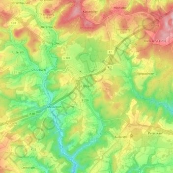
Name: Ulmen topographic map, elevation, terrain.
Average elevation: 455 m
Minimum elevation: 352 m
Maximum elevation: 573 m
Thank you for supporting this site ❤️
Make a donation
Make a donation
Other topographic maps
Click on a map to view its topography, its elevation and its terrain.
Moselhöhe Ediger-Eller
Germany > Rhineland-Palatinate > Landkreis Cochem-Zell > Ediger-Eller
Average elevation: 285 m