
Briançon topographic map
Interactive map
Click on the map to display elevation.
About this map
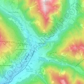
Name: Briançon topographic map, elevation, terrain.
Average elevation: 1,614 m
Minimum elevation: 1,160 m
Maximum elevation: 2,597 m
Briançon (French: [bʁijɑ̃sɔ̃] , Occitan: [bɾjanˈsun]) is the sole subprefecture of the Hautes-Alpes department in the Provence-Alpes-Côte d'Azur region in Southeastern France. It is the highest city in France at an altitude of 1,326 metres (4,350 feet), based on the national definition as a community containing more than 2,000 inhabitants. Its most recent population estimate is 11,084 (as of 2018) for the commune.
Other topographic maps
Click on a map to view its topography, its elevation and its terrain.
Gap
France > Provence-Alpes-Côte d'Azur > Hautes-Alpes
Gap, Hautes-Alpes, Provence-Alpes-Côte d'Azur, Metropolitan France, 05000, France
Average elevation: 1,146 m