
Thank you for supporting this site ❤️
Make a donation
Make a donation
Tagaytay topographic map
Click on the map to display elevation.
Thank you for supporting this site ❤️
Make a donation
Make a donation
Tagaytay
It is one of the country's most popular destinations for domestic tourism because of its scenery and cooler climate provided by its altitude. Tagaytay overlooks Taal Lake in Batangas and provides views of Taal Volcano Island in the middle of the lake through various vantage points situated in the city.
Thank you for supporting this site ❤️
Make a donation
Make a donation
About this map
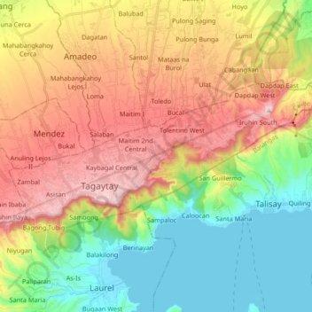
Name: Tagaytay topographic map, elevation, terrain.
Location: Tagaytay, Cavite, Calabarzon, 4120, Philippines (14.07911 120.88385 14.15765 121.05140)
Average elevation: 355 m
Minimum elevation: 2 m
Maximum elevation: 691 m
Thank you for supporting this site ❤️
Make a donation
Make a donation
Other topographic maps
Click on a map to view its topography, its elevation and its terrain.