
Make a donation
Chautauqua County topographic map
Click on the map to display elevation.
Make a donation
Chautauqua County
The county is generally composed of rolling hills and valleys, with elevations ranging anywhere between 1100 and 2100 feet, although the land within a few miles of Lake Erie is generally flat and at an elevation of 1000 feet or lower. The lowest point in the county is Lake Erie, at 571 feet (174 meters), and the highest point is Gurnsey Benchmark at 2,180 feet (660 meters).
Make a donation
About this map
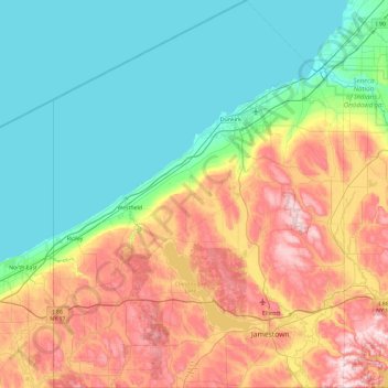
Name: Chautauqua County topographic map, elevation, terrain.
Location: Chautauqua County, New York, United States (41.99833 -79.76198 42.69246 -79.05921)
Average elevation: 328 m
Minimum elevation: 170 m
Maximum elevation: 667 m
Make a donation
Other topographic maps
Click on a map to view its topography, its elevation and its terrain.
Central Park
United States > New York > New York County > New York
In June 1856, Fernando Wood appointed a "consulting board" of seven people, headed by author Washington Irving, to inspire public confidence in the proposed development. Wood hired military engineer Egbert Ludovicus Viele as the park's chief engineer, tasking him with a topographical survey of the site. The…
Average elevation: 26 m
Make a donation
Jayne's Hill
United States > New York > Suffolk County > Town of Huntington
Jayne's Hill (also known as High Hill, West Hills, Oakley's Hill, and Janes Hill) is the highest point on Long Island, New York, with an elevation of between 387 feet (118 m) and 400.9 feet (122.2 m) above sea level. It is situated on the Harbor Hill moraine, a terminal moraine that makes up the northern spine…
Average elevation: 73 m
South Salem
United States > New York > Westchester County > Town of Lewisboro
Average elevation: 174 m
Make a donation
Make a donation
Whitesville
United States > New York > Allegany County > Town of Independence
Average elevation: 611 m
Hartmans Corners
United States > New York > Albany County > Town of Guilderland
Average elevation: 81 m
Make a donation
Make a donation
Pleasantside
United States > New York > Westchester County > Town of Cortlandt
Average elevation: 108 m
Make a donation
Make a donation
Make a donation
Make a donation
Inwood Hill Park
United States > New York > New York County > New York
Inwood Hill Park is a 196 acres (79 ha) public park in the Inwood neighborhood of Manhattan, New York City, operated by the New York City Department of Parks and Recreation. On a high schist ridge that rises 200 feet (61 m) above the Hudson River from Dyckman Street to the northern tip of the island, Inwood…
Average elevation: 14 m
Brooklyn Bridge Park
United States > New York > Kings County > New York
Brooklyn Bridge Park spans 85 acres (34 ha) of the East River waterfront in the Brooklyn Heights and Dumbo neighborhoods of Brooklyn. The park is divided into eleven sections: Piers 1 through 6; Fulton Ferry Landing; Brooklyn Bridge Plaza; Empire Fulton Ferry; Main Street; and John Street. Each of these…
Average elevation: 9 m
Make a donation
Catamount Mountain
United States > New York > Saint Lawrence County > Town of Colton
Average elevation: 433 m
Oscawana Corners
United States > New York > Putnam County > Town of Putnam Valley
Average elevation: 158 m
Make a donation
Make a donation
Make a donation
Woodcock Mountain
United States > New York > Saratoga County > Town of Hadley
Average elevation: 271 m
Make a donation
Constantia Center
United States > New York > Oswego County > Town of Constantia
Average elevation: 169 m
South New Berlin
United States > New York > Chenango County > Town of New Berlin
Average elevation: 380 m
Make a donation
Coney Island
United States > New York > Saint Lawrence County > Town of Pierrepont
Average elevation: 174 m
Make a donation
Make a donation
Make a donation
Make a donation
Sunset Ridge
United States > New York > Westchester County > Town/Village of Harrison
Average elevation: 27 m
Make a donation
Make a donation
Ellicottville
United States > New York > Cattaraugus County > Village of Ellicottville
Average elevation: 573 m
Make a donation
Make a donation
East Poestenkill
United States > New York > Rensselaer County > Town of Poestenkill
Average elevation: 376 m
Make a donation
Chenango Lake
United States > New York > Chenango County > Town of New Berlin
Average elevation: 513 m
Make a donation