
Make a donation
Northland topographic map
Click on the map to display elevation.
Make a donation
About this map
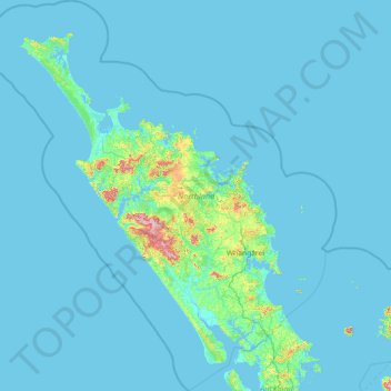
Name: Northland topographic map, elevation, terrain.
Location: Northland, New Zealand (-36.55863 172.39284 -34.19354 174.99357)
Average elevation: 23 m
Minimum elevation: 0 m
Maximum elevation: 784 m
Make a donation
Other topographic maps
Click on a map to view its topography, its elevation and its terrain.
Wellington
New Zealand > Wellington > Wellington City
Averaging 2,055 hours of sunshine per year, the climate of Wellington is temperate marine, (Köppen: Cfb, Trewartha: Cflk), generally moderate all year round with mild summers and cool to mild winters, and rarely sees temperatures above 26 °C (79 °F) or below 4 °C (39 °F). The hottest recorded temperature…
Average elevation: 85 m
Auckland
Auckland’s topography is uniquely shaped by its position on a narrow, undulating isthmus between the Waitematā Harbour to the north and the Manukau Harbour to the south, creating a landscape defined by low coastal plains interrupted by abrupt volcanic relief. The city stands atop the Auckland Volcanic…
Average elevation: 32 m
Make a donation