
Thank you for supporting this site ❤️
Make a donation
Make a donation
Inhambane Province topographic map
Click on the map to display elevation.
Thank you for supporting this site ❤️
Make a donation
Make a donation
About this map
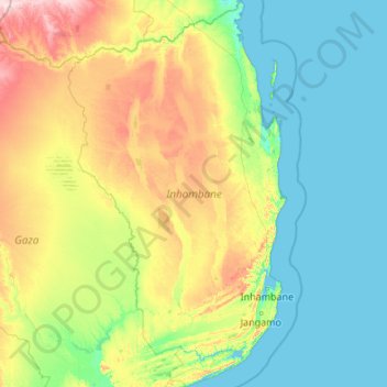
Name: Inhambane Province topographic map, elevation, terrain.
Location: Inhambane Province, Mozambique (-24.86293 33.16116 -20.88509 35.60328)
Average elevation: 70 m
Minimum elevation: -2 m
Maximum elevation: 464 m
Thank you for supporting this site ❤️
Make a donation
Make a donation
Other topographic maps
Click on a map to view its topography, its elevation and its terrain.