
Thank you for supporting this site ❤️
Make a donation
Make a donation
Trondheim topographic map
Click on the map to display elevation.
Thank you for supporting this site ❤️
Make a donation
Make a donation
Trondheim
Trondheim has a mild climate for its northerly latitude, resulting in moderate summers and winters that often remain above the freezing point in seaside areas. At higher elevations, though, the microclimate is colder and snowier.
Thank you for supporting this site ❤️
Make a donation
Make a donation
About this map
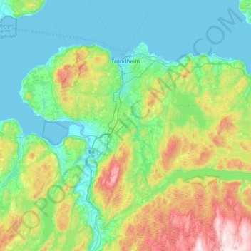
Name: Trondheim topographic map, elevation, terrain.
Location: Trondheim, Trøndelag, Norway (63.15990 10.00353 63.51659 10.72520)
Average elevation: 192 m
Minimum elevation: -2 m
Maximum elevation: 813 m
Thank you for supporting this site ❤️
Make a donation
Make a donation