
Saint Mary's County topographic map
Interactive map
Click on the map to display elevation.
About this map
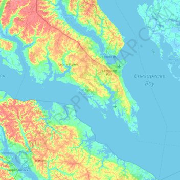
Name: Saint Mary's County topographic map, elevation, terrain.
Location: Saint Mary's County, Maryland, USA (37.89033 -76.87435 38.51371 -76.19967)
Average elevation: 13 m
Minimum elevation: -4 m
Maximum elevation: 62 m
Other topographic maps
Click on a map to view its topography, its elevation and its terrain.
Cockeysville
USA > Maryland > Cockeysville
Cockeysville, Baltimore County, Maryland, 21031, USA
Average elevation: 131 m
Grahams Green Acres
USA > Maryland > Grahams Green Acres
Grahams Green Acres, Carroll County, Maryland, 21776, USA
Average elevation: 223 m