Dubai Emirate topographic map
Click on the map to display elevation.
Dubai Emirate
Dubai lies directly in the Arabian Desert. Still, its topography differs significantly from that of the southern UAE, with much of Dubai's landscape characterized by sandy desert patterns. In contrast, gravel deserts dominate much of the country's south. The sand consists mostly of crushed shells and coral and is fine, clean, and white. East of the city, the salt-crusted coastal plains, known as sabkha, give way to a north–south running line of dunes. Farther east, the dunes grow larger and are tinged red with iron oxide.
About this map
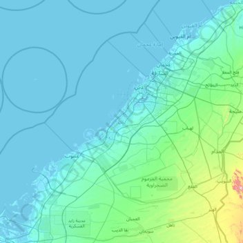
Name: Dubai Emirate topographic map, elevation, terrain.
Location: Dubai Emirate, Dubai, United Arab Emirates (24.62307 54.71540 25.52507 56.20530)
Average elevation: 64 m
Minimum elevation: -9 m
Maximum elevation: 1,042 m
Other topographic maps
Click on a map to view its topography, its elevation and its terrain.

Hatta
Due to Hatta's higher altitude, its climate is much cooler than central Dubai. Hatta has an arid landscape and temperature, reaching 55 degrees Celsius in the summer; however, it is less humid than Dubai and far colder in the winter.
Average elevation: 431 m




Hatta
Due to Hatta's higher altitude, its climate is much cooler than central Dubai. Hatta has an arid landscape and temperature, reaching 55 degrees Celsius in the summer; however, it is less humid than Dubai and far colder in the winter.
Average elevation: 371 m




Hatta
Due to Hatta's higher altitude, its climate is much cooler than central Dubai. Hatta has an arid landscape and temperature, reaching 55 degrees Celsius in the summer; however, it is less humid than Dubai and far colder in the winter.
Average elevation: 371 m

Hatta
Due to Hatta's higher altitude, its climate is much cooler than central Dubai. Hatta has an arid landscape and temperature, reaching 55 degrees Celsius in the summer; however, it is less humid than Dubai and far colder in the winter.
Average elevation: 371 m