
Make a donation
Dolores County topographic map
Click on the map to display elevation.
Make a donation
Dolores County
Dolores County, like other counties in Colorado along its border with Utah, is split into two geographically distinct regions, and in fact, under normal travel conditions, it is necessary to leave the county to travel between the two regions. The western portion of the county (east of the Dolores River Canyon and along the Utah border) is the northern portion of the Great Sage Plain, relatively low 6,500–7,500 ft (2,000–2,300 m) in elevation and flat (but cut by large canyons, including that of the Dolores River itself), and consists of irrigated and dryland farming areas; it is especially well known for the cultivation of various varieties of beans, including pinto beans and many variety of old Anasazi beans. The central portion of the county has higher open grasslands with forested hills, ravines, and canyons, used for livestock raising. The eastern portion of the county is located in the highest peaks of the San Juan Mountains, around the old mining and modern tourist town of Rico, and except for cattle grazing in the San Juan National Forest, has virtually no agriculture, in part because its elevations range from 9,000 to 14,000 ft (2,700 to 4,300 m). Rico is developing in many ways as a bedroom community for the much wealthier town of Telluride in San Miguel County to the north.
Make a donation
About this map
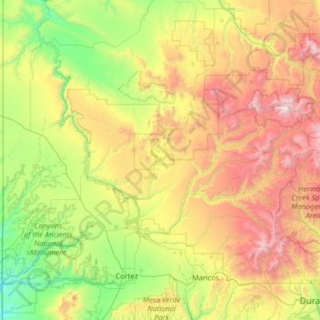
Name: Dolores County topographic map, elevation, terrain.
Location: Dolores County, Colorado, United States (37.48417 -109.04338 37.89554 -107.86085)
Average elevation: 2,385 m
Minimum elevation: 1,472 m
Maximum elevation: 4,252 m
Make a donation
Other topographic maps
Click on a map to view its topography, its elevation and its terrain.
Evergreen
United States > Colorado > Jefferson County
Evergreen sits at an elevation of 7,220 feet (2,200 m) in the Rocky Mountains, 19 miles west of Denver, Colorado. Its addresses are oriented according to the Street_system_of_Denver.
Average elevation: 2,309 m
Make a donation
Make a donation
Humboldt Peak
United States > Colorado > Custer County
According to the Köppen climate classification system, Humboldt is located in an alpine subarctic climate zone with cold, snowy winters, and cool to warm summers. Due to its altitude, it receives precipitation all year, as snow in winter, and as thunderstorms in summer, with a dry period in late spring.
Average elevation: 3,738 m
Make a donation
Castle Peak
United States > Colorado > Pitkin County
There are two other peaks in Colorado that have the same name: one in Eagle County at 39°46′23″N 106°50′04″W / 39.7730422°N 106.8344844°W / 39.7730422; -106.8344844, with an elevation 11,280+ feet, (3438+ m); and the other in Mesa County at 39°16′16″N 108°05′40″W /…
Average elevation: 3,909 m
Make a donation
Torreys Peak
United States > Colorado > Clear Creek County
The third trail starts at Loveland Pass about 4.5 miles (7.2 km) to the northwest. To reach Loveland Pass, follow I-70 west from Denver 55 miles (89 km) to where US Route 6 breaks off and heads south. Follow the meandering Route 6 approximately seven miles to the trailhead at Loveland Pass, at an elevation of…
Average elevation: 3,854 m
Quandary Peak
United States > Colorado > Summit County
Quandary Peak is the highest summit of the Tenmile Range in the Rocky Mountains of North America at 14,271 ft (4,350 m). As of 2018, it was the most commonly climbed fourteener in Colorado. It has nearly the same elevation as Castle Peak and Mount Blue Sky. It lies in Summit County and within the White River…
Average elevation: 3,833 m
Make a donation
Mount Harvard
United States > Colorado > Chaffee County
In 1962, three Harvard men attempted to erect a fourteen-foot metal pole on the top of Harvard, with a sign that read "Mt. Harvard, 14,434. This sign erected at an altitude of 14,434 making it the second highest point in the contiguous United States." Before they could reach the top of the mountain darkness…
Average elevation: 3,936 m
Make a donation
Fairplay
United States > Colorado > Park County
The historic Town of Fairplay is the Statutory Town that is the county seat and the most populous municipality of Park County, Colorado, United States. The town population was 724 at the 2020 United States Census. Fairplay is located in South Park at an elevation of 9,953 feet (3,034 m). The town is the…
Average elevation: 3,045 m
Estes Park
United States > Colorado > Larimer County
Estes Park sits at an elevation of 7,522 feet (2,293 m) on the front range of the Rocky Mountains at the eastern entrance of the Rocky Mountain National Park. Its north, south and east extremities border the Roosevelt National Forest. Lumpy Ridge lies immediately north of Estes Park.
Average elevation: 2,543 m
Make a donation
Lakewood
United States > Colorado > Jefferson County > Lakewood
Lakewood is located at 39°42′17″N 105°04′53″W / 39.70472°N 105.08139°W / 39.70472; -105.08139 at an elevation of 5,518 feet (1,682 m). Located at the junction of U.S. Route 6 and Colorado State Highway 121 in central Colorado, the city lies immediately west of Denver and 62 miles (100 km)…
Average elevation: 1,717 m
Make a donation
Make a donation
Vail
United States > Colorado > Eagle County
Vail's average elevation is 8,150 feet (2484 m) above sea level. The town has a total area of 4.5 square miles (12 km2), with no lakes (there is, however, at least one pond). Gore Creek flows from east to west through the center of town.
Average elevation: 2,953 m
Pikes Peak
United States > Colorado > El Paso County
Pikes Peak or America's Mountain is an ultra-prominent fourteener of the Front Range of the Rocky Mountains of North America. Pikes Peak's summit has an elevation of 14,115 ft (4,302 m) above sea level. Pikes Peak is in Pike National Forest, Colorado, with the base located in the town of Manitou Springs, 10…
Average elevation: 3,902 m
Make a donation
Rogers Pass
United States > Colorado > Gilpin County
Rogers Pass, elevation 11,866 ft (3,617 m), is a mountain pass in the Front Range of central Colorado. The pass crosses the continental divide in the James Peak Wilderness.
Average elevation: 3,448 m
Grand Lake
United States > Colorado > Grand County
Established in 1881, Grand Lake sits at an elevation of 8,369 feet (2,551 m) and derives its name from the lake on whose shores it is situated: Grand Lake, the largest natural body of water in Colorado. The town of Grand Lake was originally an outfitting and supply point for the mining settlements of Lulu…
Average elevation: 2,630 m
Make a donation
Crested Butte
United States > Colorado > Gunnison County
Crested Butte is located in north-central Gunnison County on the west side of the valley of the Slate River, along Coal Creek. Colorado State Highway 135 runs south from Crested Butte 27 miles (43 km) to Gunnison, the county seat. According to the United States Census Bureau, the town of Crested Butte has a…
Average elevation: 2,798 m
Make a donation
Argentine Pass
United States > Colorado > Summit County
Argentine Pass, elevation 13,207 ft (4,025 m), is a high mountain pass that crosses the Continental Divide in the Front Range of the Rocky Mountains of central Colorado in the United States. Argentine Pass is located on the crest of the Front Range along the boundary southwest of Georgetown and is the highest…
Average elevation: 3,797 m
Make a donation
Make a donation
Mount Blue Sky
United States > Colorado > Clear Creek County
The history of the Mount Blue Sky Scenic Byway is part of a larger story of the Denver Mountain Parks system. The City and County of Denver initiated the construction of a series of automobile "scenic loops" to allow Denverites to explore the mountains. One road circuit, Circle G, was to traverse the ridge to…
Average elevation: 4,006 m
Make a donation
Make a donation
South Boulder Canyon Ditch
United States > Colorado > Boulder County > Lafayette
Average elevation: 1,618 m
Loveland Pass
United States > Colorado > Clear Creek County
Loveland Pass is a high mountain pass in north-central Colorado, at an elevation of 11,990 feet (3,655 m) above sea level in the Rocky Mountains of the Western United States.
Average elevation: 3,639 m
Make a donation
Make a donation
Make a donation
Make a donation
La Poudre Pass
United States > Colorado > Larimer County
La Poudre Pass (elevation 10,184 ft (3,104 m)), a high mountain pass, is located in the Rocky Mountains of northern Colorado in the United States.
Average elevation: 3,218 m
Make a donation
Alamo Square Park
United States > Colorado > El Paso County > Colorado Springs
Average elevation: 1,831 m
Make a donation
Indiana Street Open Space
United States > Colorado > Jefferson County > Arvada
Average elevation: 1,699 m
Conifer
United States > Colorado > Jefferson County
Conifer is located in Jefferson County at coordinates 39°31′16″N 105°18′19″W / 39.5211°N 105.3053°W / 39.5211; -105.3053 (Conifer, Colorado) and elevation 8,262 feet (2,518 m).
Average elevation: 2,573 m
Make a donation
Make a donation
Mount Massive
United States > Colorado > Lake County
A class 2 hiking path leads to the peak from the eastern face. The path is 13.6 mi (21.9 km) round trip, with a 4,500 ft (1,400 m) elevation gain. There is also a class 2 route along the southwest slopes.
Average elevation: 4,021 m
Make a donation