
Thank you for supporting this site ❤️
Make a donation
Make a donation
Vallegrande topographic map
Click on the map to display elevation.
Thank you for supporting this site ❤️
Make a donation
Make a donation
Vallegrande
The town lies in a big valley (hence the name) at an altitude of 2,030 m (6,660 ft) and has approximately 6,000 inhabitants. It has a mild temperate climate due mainly to its valley location, altitude, and the cold winter fronts the sweep the plains of Santa Cruz known as "Surazo".
Thank you for supporting this site ❤️
Make a donation
Make a donation
About this map
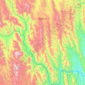
Name: Vallegrande topographic map, elevation, terrain.
Location: Vallegrande, Santa Cruz, Bolivia (-19.18451 -64.30318 -18.29254 -63.53131)
Average elevation: 1,694 m
Minimum elevation: 505 m
Maximum elevation: 3,430 m
Thank you for supporting this site ❤️
Make a donation
Make a donation