
Mendip topographic map
Interactive map
Click on the map to display elevation.
About this map
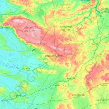
Name: Mendip topographic map, elevation, terrain.
Location: Mendip, Somerset, South West England, England, United Kingdom (51.06329 -2.84269 51.32571 -2.24440)
Average elevation: 98 m
Minimum elevation: -1 m
Maximum elevation: 323 m
Other topographic maps
Click on a map to view its topography, its elevation and its terrain.
Wells
United Kingdom > England > Mendip
Wells, Mendip, Somerset, South West England, England, United Kingdom
Average elevation: 68 m