
Thank you for supporting this site ❤️
Make a donation
Make a donation
Šabac topographic map
Click on the map to display elevation.
Thank you for supporting this site ❤️
Make a donation
Make a donation
About this map
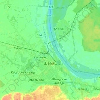
Name: Šabac topographic map, elevation, terrain.
Average elevation: 81 m
Minimum elevation: 69 m
Maximum elevation: 105 m
Thank you for supporting this site ❤️
Make a donation
Make a donation
Other topographic maps
Click on a map to view its topography, its elevation and its terrain.
Тришићи
Serbia > Central Serbia > Macva Administrative District > Mali Zvornik Municipality
Average elevation: 280 m