
Canterbury topographic map
Interactive map
Click on the map to display elevation.
About this map
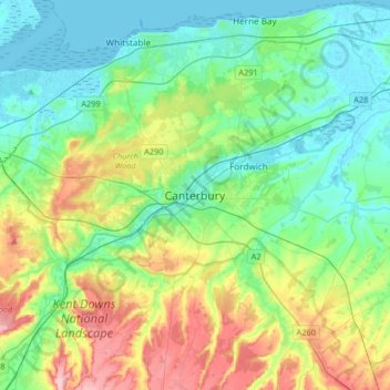
Name: Canterbury topographic map, elevation, terrain.
Location: Canterbury, Kent, England, United Kingdom (51.17719 0.93720 51.38254 1.25007)
Average elevation: 51 m
Minimum elevation: -1 m
Maximum elevation: 178 m
Other topographic maps
Click on a map to view its topography, its elevation and its terrain.
Gordon Lake
United Kingdom > England > Kent > Gravesham > Gravesend
Gordon Lake, Milton, Gravesend, Gravesham, Kent, England, United Kingdom
Average elevation: 11 m