
Thank you for supporting this site ❤️
Make a donation
Make a donation
Samosir topographic map
Click on the map to display elevation.
Thank you for supporting this site ❤️
Make a donation
Make a donation
About this map
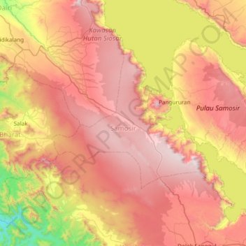
Name: Samosir topographic map, elevation, terrain.
Location: Samosir, North Sumatra, Sumatra, Indonesia (2.35197 98.39956 2.76053 98.99297)
Average elevation: 1,215 m
Minimum elevation: 212 m
Maximum elevation: 2,126 m
Thank you for supporting this site ❤️
Make a donation
Make a donation
Other topographic maps
Click on a map to view its topography, its elevation and its terrain.