
Thank you for supporting this site ❤️
Make a donation
Make a donation
Crato topographic map
Click on the map to display elevation.
Thank you for supporting this site ❤️
Make a donation
Make a donation
Crato
Crato is about 550 km from Fortaleza, the capital of the state of Ceará. Its county has a surface area of approximately 1,117 km2. It is at an altitude of 426m, 07°14′03″S 39°24′34″W / 7.23417°S 39.40944°W / -7.23417; -39.40944. Its population of 110,000 makes it the sixth-largest city in Ceará. The economy is a mix of trading and agriculture; as of 2004, a small industrial park is expanding. The region is rich in minerals, especially gypsum and marble.
Thank you for supporting this site ❤️
Make a donation
Make a donation
About this map
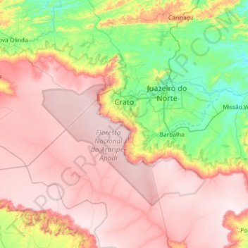
Name: Crato topographic map, elevation, terrain.
Average elevation: 677 m
Minimum elevation: 324 m
Maximum elevation: 999 m
Thank you for supporting this site ❤️
Make a donation
Make a donation
Other topographic maps
Click on a map to view its topography, its elevation and its terrain.
Thank you for supporting this site ❤️
Make a donation
Make a donation
Thank you for supporting this site ❤️
Make a donation
Make a donation
Thank you for supporting this site ❤️
Make a donation
Make a donation
Thank you for supporting this site ❤️
Make a donation
Make a donation
Thank you for supporting this site ❤️
Make a donation
Make a donation