
Thank you for supporting this site ❤️
Make a donation
Make a donation
Sermersooq topographic map
Click on the map to display elevation.
Thank you for supporting this site ❤️
Make a donation
Make a donation
About this map
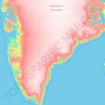
Name: Sermersooq topographic map, elevation, terrain.
Location: Sermersooq, Greenland (60.85019 -52.79009 71.94284 -20.78094)
Average elevation: 1,116 m
Minimum elevation: -2 m
Maximum elevation: 3,402 m
Thank you for supporting this site ❤️
Make a donation
Make a donation
Other topographic maps
Click on a map to view its topography, its elevation and its terrain.