
Paraná topographic map
Interactive map
Click on the map to display elevation.
Paraná
The state can be separated into five main topographic areas, from east to west: a coastal zone, the mountains of Serra do Mar, and then three plateaus, each lower than the other, until the Paraná River is reached.
About this map
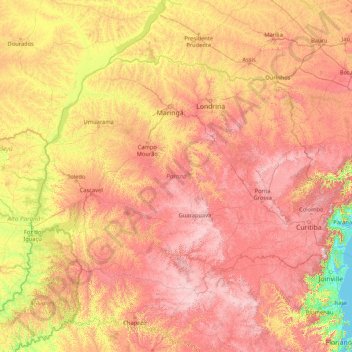
Name: Paraná topographic map, elevation, terrain.
Location: Paraná, South Region, Brazil (-26.72090 -54.61986 -22.51600 -47.85611)
Average elevation: 548 m
Minimum elevation: -1 m
Maximum elevation: 1,585 m
Other topographic maps
Click on a map to view its topography, its elevation and its terrain.
Atlantic Forest
Brazil > São Paulo > Região Metropolitana de São Paulo > Ribeirão Pires
Average elevation: 787 m