
Make a donation
Ragogna topographic map
Click on the map to display elevation.
Make a donation
About this map
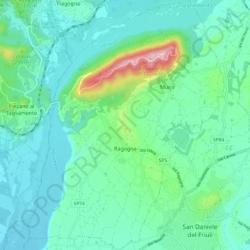
Name: Ragogna topographic map, elevation, terrain.
Location: Ragogna, Udine, Friuli-Venezia Giulia, Italy (46.14845 12.94782 46.21011 13.01773)
Average elevation: 191 m
Minimum elevation: 118 m
Maximum elevation: 498 m
Make a donation
Other topographic maps
Click on a map to view its topography, its elevation and its terrain.
Trinco / Trinko
Italy > Friuli-Venezia Giulia > Udine > Drenchia > Drenchia / Dreka
Average elevation: 742 m
Make a donation
Tolmezzo
Italy > Friuli-Venezia Giulia > Udine > Tolmezzo > Tolmezzo
Tolmezzo is located at the foot of the Strabut Mountain, between the Tagliamento River and the Bût stream. Nearby is the Mount Amariana, elevation 1,906 metres (6,253 ft). The commune also includes the five frazioni of Cadunea (Friulian: Cjadugnee), Caneva (Cjanive), Casanova (Cjasegnove), Fusea (Fusee),…
Average elevation: 563 m
Make a donation
Make a donation