
Make a donation
Piedmont topographic map
Click on the map to display elevation.
Make a donation
Piedmont
Piedmont has a typically temperate climate, which on the Alps becomes progressively temperate-cold and colder as it climbs to altitude. In areas located at low altitudes, winters are relatively cold but not very rainy and often sunny, with the possibility of snowfall, sometimes abundant. Snowfall, on the other hand, is less frequent and occasional in the northeast areas. Summers are hot with local possibilities of strong thunderstorms.
Make a donation
About this map
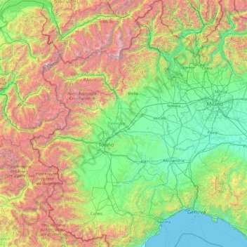
Name: Piedmont topographic map, elevation, terrain.
Location: Piedmont, Italy (44.05972 6.62727 46.46422 9.21424)
Average elevation: 1,082 m
Minimum elevation: 0 m
Maximum elevation: 4,564 m
Make a donation
Other topographic maps
Click on a map to view its topography, its elevation and its terrain.
Make a donation
Großhorn - Corno Grande
Italy > Trentino-Alto Adige/Südtirol > Graun - Curon Venosta
Average elevation: 2,295 m
Make a donation