
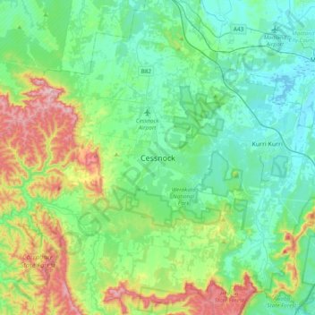
Cessnock topographic map
Click on the map to display elevation.
About this map
Name: Cessnock topographic map, elevation, terrain.
Average elevation: 142 m
Minimum elevation: -1 m
Maximum elevation: 580 m
Other topographic maps
Click on a map to view its topography, its elevation and its terrain.
Sydney
Sydney's topography is characterized by a diverse landscape that seamlessly blends coastal features with inland plateaus. The city is divided into two primary regions: the relatively flat Cumberland Plain to the south and west of Sydney Harbour, and the elevated Hornsby Plateau to the north. The Cumberland…
Average elevation: 53 m
Byron Bay
Byron Bay, located in northeastern New South Wales, Australia, is characterized by diverse topography shaped by its geological history. The town is part of the erosion caldera of the ancient Tweed Volcano, which erupted approximately 23 million years ago, resulting in the rich volcanic soils that define the…
Average elevation: 7 m
Goulburn
Owing to its elevation, Goulburn has an oceanic climate (Cfb) with warm summers and cool winters; with a high diurnal range. Its climate is variable much of the year, though generally dry with maximum temperatures ranging from 11.8 °C (53.2 °F) in July to 28.3 °C (82.9 °F) in January. Rainfall is…
Average elevation: 666 m
Terrey Hills
Australia > New South Wales > Sydney
Owing to its elevation and close proximity to the ocean, as well as its extensive tree canopy cover, the weather station at Terrey Hills records the mildest temperatures of any weather station in the Greater Sydney region. Under Köppen's scheme, the suburb has a borderline humid subtropical (Cfa) and oceanic…
Average elevation: 146 m
Mooney Mooney
Its topography is characterised by a rocky foreshore onto the Hawkesbury River and a hilly landscape with slopes ranging from moderate to very steep. Land use is dominated by the north–south transport corridors, comprising the M1 Pacific Motorway and the Pacific Highway, and two adjoining residential areas…
Average elevation: 32 m
Adaminaby
Another site 20 km to the north (Yaouk, since 1969) records significantly greater rainfall due to its higher elevation and proximity to the dividing range. This site is most representative of the areas situated on and around Lake Eucumbene. Rainfall total and pattern here approach those of Khancoban and very…
Average elevation: 1,174 m
Gundagai
Gundagai is an inland town with an elevation of 232 metres (761 ft). Almost all of the shire is located in the South West Slopes bio-region and is part of the Riverina agricultural region. The eastern part of the shire is considered part of the South Eastern Highlands bioregion.
Average elevation: 309 m