
Make a donation
Boticas topographic map
Click on the map to display elevation.
Make a donation
Boticas
One of the symbols of Boticas is the Galaico Warrior, an anthropomorphic carved monolith (found in the 17th century) in the castro of Lesenho, at an altitude of 1075 metres, under fields of the parish of São Salvador de Viveiro and the municipality of Boticas, considered the most important Gallaecian castro in Portugal. The Galaico (or "Castrejo") Warrior is an important example of Portuguese archaeology and represents, according to several experts, the image of a deity and warrior of the "castreja" civilisation that lived in this area of Portugal.
Make a donation
About this map
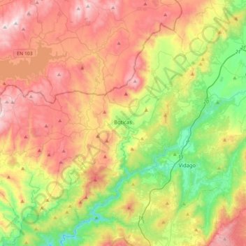
Name: Boticas topographic map, elevation, terrain.
Location: Boticas, Vila Real, Portugal (41.57850 -7.91787 41.79530 -7.56273)
Average elevation: 701 m
Minimum elevation: 227 m
Maximum elevation: 1,276 m
Make a donation
Other topographic maps
Click on a map to view its topography, its elevation and its terrain.
Cidadelha de Jales
Portugal > Vila Real > Vila Pouca de Aguiar > Alfarela de Jales
Average elevation: 783 m
Make a donation
Soutelinho do Monte
Portugal > Vila Real > Vila Pouca de Aguiar > Vreia de Bornes
Average elevation: 577 m
Make a donation
Make a donation
Make a donation
Ribeira de Pena
Portugal > Vila Real > Ribeira de Pena (Salvador) e Santo Aleixo de Além-Tâmega > Ribeira de Pena
Average elevation: 570 m
Make a donation