
Río Negro Province topographic map
Interactive map
Click on the map to display elevation.
Río Negro Province
The climate of the province is temperate at low elevations, and very cold in the higher Andean peaks.
About this map
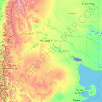
Name: Río Negro Province topographic map, elevation, terrain.
Location: Río Negro Province, Argentina (-41.99209 -71.91207 -37.57478 -62.78956)
Average elevation: 621 m
Minimum elevation: -71 m
Maximum elevation: 4,505 m
Other topographic maps
Click on a map to view its topography, its elevation and its terrain.