
Thank you for supporting this site ❤️
Make a donation
Make a donation
Porto Santo topographic map
Click on the map to display elevation.
Thank you for supporting this site ❤️
Make a donation
Make a donation
About this map
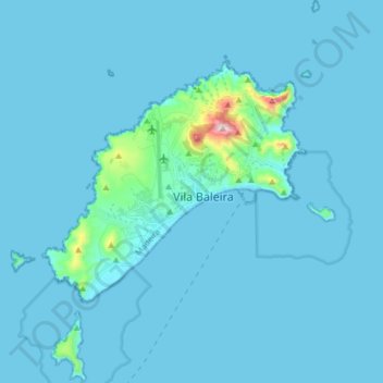
Name: Porto Santo topographic map, elevation, terrain.
Location: Porto Santo, Madeira, Portugal (32.99612 -16.41074 33.12816 -16.27738)
Average elevation: 22 m
Minimum elevation: -2 m
Maximum elevation: 484 m
Thank you for supporting this site ❤️
Make a donation
Make a donation
Other topographic maps
Click on a map to view its topography, its elevation and its terrain.