
Make a donation
Henderson County topographic map
Click on the map to display elevation.
Make a donation
Henderson County
Due to its geographic setting along the Eastern Continental Divide and its extreme topographic variation, Henderson County presents a wide variation in temperature and precipitation conditions. The highest elevations occur along the northwest and northern boundaries of the county and within the Blue Ridge Escarpment, a rugged area of peaks and narrow valleys that rise from the Piedmont to the continental divide and the Blue Ridge Plateau. The lowest elevations occur within the valleys of the escarpment and in the broader valleys of the Blue Ridge Plateau. The mean annual temperature of the county is 55.1 °F (12.8 °C), with a range from 50.3 to 57.9 °F (10.2 to 14.4 °C) depending on the elevation, with higher temperatures occurring at lower elevations and lower temperatures in the higher mountains. The month of July is the hottest in the county, with a mean temperature of 72.6 °F (22.6 °C) and a mean range of 66.6 to 75.8 °F (19.2 to 24.3 °C). The coolest month is January with a mean temperature of 36.9 °F (2.7 °C) and a mean range of 33.3 to 39.5 °F (0.7 to 4.2 °C). Precipitation is also correlated to elevation, with higher precipitation normally occurring at higher elevations and lower precipitation in the valleys. The mean annual precipitation of Henderson County is 56.2 inches (1,430 mm), with a mean range of 45.04 to 78.03 inches (1,144 to 1,982 mm). March has the highest mean precipitation of 5.1 inches (130 mm), with a mean range of 3.9 to 6.7 inches (99 to 170 mm). The lowest precipitation occurs in October, with a mean value of 3.9 inches (99 mm) and a mean range of 2.8 to 5.8 inches (71 to 147 mm).
Make a donation
About this map
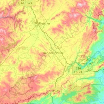
Name: Henderson County topographic map, elevation, terrain.
Location: Henderson County, North Carolina, United States (35.14419 -82.74515 35.50022 -82.26116)
Average elevation: 703 m
Minimum elevation: 276 m
Maximum elevation: 1,325 m
Make a donation
Other topographic maps
Click on a map to view its topography, its elevation and its terrain.
Appalachian Mountains
United States > North Carolina > Yancey County
The Appalachian Mountains (French: Appalaches), often called the Appalachians, are a system of mountains in eastern to northeastern North America. The Appalachians first formed roughly 480 million years ago during the Ordovician Period. They once reached elevations similar to those of the Alps and the Rocky…
Average elevation: 1,463 m
Make a donation
Make a donation
Bald Head Island
United States > North Carolina > Brunswick County > Bald Head Island
Average elevation: 3 m
Kuwohi
United States > North Carolina > Swain County
At an elevation of 6,643 feet (2,025 m), it is the highest mountain in the Great Smoky Mountains National Park, the highest point in the state of Tennessee, and the highest point along the 2,192-mile (3,528 km) Appalachian Trail. It is also the third highest point in eastern mainland North America, after Mount…
Average elevation: 1,716 m
Highlands
United States > North Carolina > Macon County > Highlands
Highlands was founded in 1875 after its two founders, Samuel Truman Kelsey and Clinton Carter Hutchinson, drew lines from Chicago to Savannah and from New Orleans to New York City. They felt that the place where these lines met would eventually become a great trading center and commercial crossroads. Highlands…
Average elevation: 1,090 m
Make a donation
Make a donation
Make a donation
Terrell
United States > North Carolina > Catawba County
Terrell is located at 35°35′20.72″N 80°58′39.5″W / 35.5890889°N 80.977639°W / 35.5890889; -80.977639 within area code 828, ZIP code 28682, and FIPS place code 67180. It sits at an elevation of 289 m (948 ft).
Average elevation: 247 m
Make a donation
Make a donation
Cape Hatteras
United States > North Carolina > Dare County
Cape Hatteras /ˈhætərəs/ is a bend in a thin, broken strand of islands in North Carolina that arch out into the Atlantic Ocean away from the US mainland, then back toward the mainland, creating a series of sheltered islands between the Outer Banks and the mainland. For thousands of years these barrier…
Average elevation: 1 m
Make a donation
Make a donation
Mount Mitchell
United States > North Carolina > Yancey County
Mount Mitchell, known in Cherokee as Attakulla, is the highest peak of the Appalachian Mountains and the highest peak in mainland eastern North America. It is located near Burnsville in Yancey County, North Carolina; in the Black Mountain subrange of the Appalachians, about 19 miles (31 km) northeast of…
Average elevation: 1,743 m
Make a donation
Make a donation
Make a donation
Valle Crucis
United States > North Carolina > Watauga County
Valle Crucis is located at the banks of Dutch Creek and Watauga River, at an elevation of 2,677 feet (816 m) above sea level. To its north and east is Tester Mountain and to its south and west is Valle Mountain. The community is also within the Pisgah National Forest boundary, which limits some development in…
Average elevation: 904 m
Providence Plantation
United States > North Carolina > Mecklenburg County > Charlotte
Average elevation: 205 m
Make a donation
Make a donation
Reedy Creek Regional Park
United States > North Carolina > Mecklenburg County > Charlotte
Average elevation: 229 m
Make a donation
Make a donation
Cul Res Town Creek Indian Mound
United States > North Carolina > Montgomery County
Average elevation: 71 m
Wilmington Beach
United States > North Carolina > New Hanover County > Carolina Beach
Average elevation: 2 m
Make a donation
Make a donation
Make a donation
Tuckaseegee Park
United States > North Carolina > Mecklenburg County > Charlotte
Average elevation: 233 m
Make a donation
Maplewood
United States > North Carolina > Richmond County > Rockingham > East Rockingham
Average elevation: 83 m
Ballantyne's Backyard
United States > North Carolina > Mecklenburg County > Charlotte
Average elevation: 183 m
Make a donation
Make a donation
Haw Creek Park
United States > North Carolina > Buncombe County > Asheville > Dogwood Grove
Average elevation: 666 m
Make a donation
Parmele Isles
United States > North Carolina > New Hanover County > Wrightsville Beach
Average elevation: 1 m
Make a donation
Spring Valley
United States > North Carolina > Mecklenburg County > Charlotte
Average elevation: 201 m
Make a donation