
Thank you for supporting this site ❤️
Make a donation
Make a donation
Covilhã topographic map
Click on the map to display elevation.
Thank you for supporting this site ❤️
Make a donation
Make a donation
Covilhã
The cold increases according to altitude, varying from higher temperatures in the lower parts of the city to negative temperatures and snow occurrences, sometimes abundant, in the higher areas, such as Penhas da Saúde, above 1,500 meters of altitude, only 9 km away from Torre (Serra da Estrela). In the urban area of Covilhã the snow rarely appears and usually does not accumulate on the ground.
Thank you for supporting this site ❤️
Make a donation
Make a donation
About this map
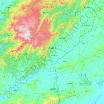
Name: Covilhã topographic map, elevation, terrain.
Location: Covilhã, Castelo Branco, Portugal (40.13004 -7.80904 40.40184 -7.34378)
Average elevation: 710 m
Minimum elevation: 343 m
Maximum elevation: 1,991 m
Thank you for supporting this site ❤️
Make a donation
Make a donation