
Make a donation
Alberta topographic map
Click on the map to display elevation.
Make a donation
About this map
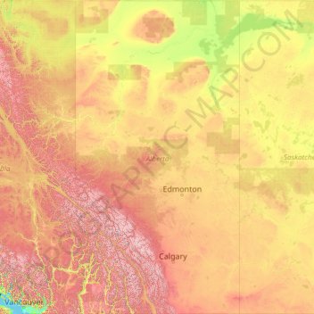
Name: Alberta topographic map, elevation, terrain.
Location: Alberta, Canada (48.99667 -120.00138 60.00047 -110.00476)
Average elevation: 806 m
Minimum elevation: 0 m
Maximum elevation: 3,512 m
Make a donation
Other topographic maps
Click on a map to view its topography, its elevation and its terrain.
Mount Columbia
Canada > Alberta > Improvement District No. 12 > Area A (Kicking Horse/Kinbasket Lake)
Average elevation: 2,843 m
Mount Royal
Canada > Quebec > Urban agglomeration of Montreal > Montreal
The mountain is part of the Monteregian Hills situated between the Laurentians and the Appalachian Mountains. It gave its Latin name, Mons Regius, to the Monteregian chain. The mountain consists of three peaks: Colline de la Croix (or Mont Royal proper) at 233 m (764 ft), Colline d'Outremont (or Mount Murray,…
Average elevation: 111 m
Make a donation
Make a donation
McMurrich
Canada > Ontario > Parry Sound District > McMurrich/Monteith Township
Average elevation: 337 m
Barrier Islands
Canada > Ontario > Kenora District > Unorganized Kenora District
Average elevation: 345 m
Make a donation