Geolocate

Hà Nội topographic map

Interactive map

Click on the map to display elevation.

About this map

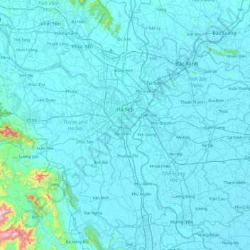
Name: Hà Nội topographic map, elevation, terrain.

Location: Hà Nội, Vietnam (20.56452 105.28896 21.38528 106.02007)

Average elevation: 41 m

Minimum elevation: -1 m

Maximum elevation: 1,138 m

Other topographic maps

Click on a map to view its topography, its elevation and its terrain.

Hoà Bình province

Vietnam

Average elevation: 240 m

Lai Châu Province

Vietnam

Average elevation: 993 m

Cà Mau Province

Vietnam

Average elevation: 1 m

Đồng Nai Province

Vietnam

Average elevation: 109 m

Quảng Nam Province

Vietnam

Quảng Nam comprises flat land along the coast and increasingly high elevations towards the west, with the highest elevations along the border to Laos and Kon Tum province. The highest peak is Ngọc Linh mountain at 2598m. In contrast to the other provinces of the South Central Coast there are no hills or…

Average elevation: 464 m

Hue

Vietnam > Thừa Thiên Huế Province > Hue City > Hue

Average elevation: 31 m

Da Nang

Vietnam > Da Nang

Geologically, Da Nang is at the edge of a Paleozoic fold belt known as the Truong Son Orogenic Zone, whose main deformation occurred during the early Carboniferous period. Da Nang's topography is dominated by the steep Annamite mountain range to the north and north-west, which features peaks ranging from 700…

Average elevation: 99 m

Hoan Kiem District

Vietnam > Hanoi

Average elevation: 14 m

Hoan Kiem

Vietnam > Hanoi > Hoan Kiem

Average elevation: 12 m

Hoan Kiem District

Vietnam > Hanoi

Average elevation: 14 m

Ngoc Hien District

Vietnam > Ca Mau province

Average elevation: 1 m