
Thank you for supporting this site ❤️
Make a donation
Make a donation
Fernão Ferro topographic map
Click on the map to display elevation.
Thank you for supporting this site ❤️
Make a donation
Make a donation
About this map
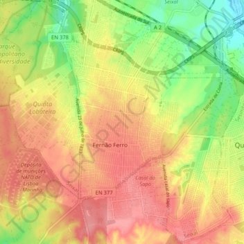
Name: Fernão Ferro topographic map, elevation, terrain.
Location: Fernão Ferro, Seixal, Setúbal, Portugal (38.54068 -9.12811 38.60168 -9.04852)
Average elevation: 51 m
Minimum elevation: 0 m
Maximum elevation: 85 m
Thank you for supporting this site ❤️
Make a donation
Make a donation
Other topographic maps
Click on a map to view its topography, its elevation and its terrain.