
Gran Canaria topographic map
Interactive map
Click on the map to display elevation.
About this map
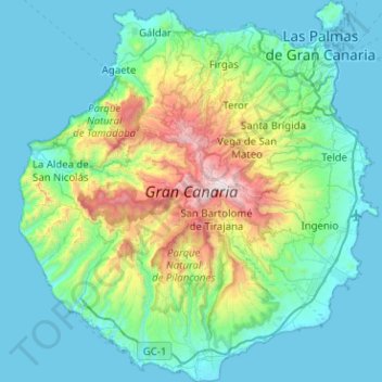
Name: Gran Canaria topographic map, elevation, terrain.
Average elevation: 335 m
Minimum elevation: -1 m
Maximum elevation: 1,933 m
Gran Canaria is located southeast of Tenerife and west of Fuerteventura. The island is of volcanic origin, mostly made of fissure vents. Gran Canaria's surface area is 1,560 km² and its maximum elevation is 1,949 metres (Pico de Las Nieves). It has a round shape, with a diameter of approximately 50 km.