
Douglas County topographic map
Interactive map
Click on the map to display elevation.
About this map
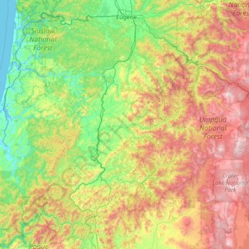
Name: Douglas County topographic map, elevation, terrain.
Location: Douglas County, Oregon, United States (42.69925 -124.29033 43.94513 -121.97429)
Average elevation: 696 m
Minimum elevation: -3 m
Maximum elevation: 2,600 m
Other topographic maps
Click on a map to view its topography, its elevation and its terrain.
Salem
United States > Oregon > Marion County
Salem, Marion County, Oregon, United States
Average elevation: 96 m
Bonneville Dam
United States > Oregon > Multnomah County > North Bonneville
Bonneville Dam, North Bonneville, Multnomah County, Oregon, United States
Average elevation: 76 m
Mount Sylvania
United States > Oregon > Lake Oswego
Mount Sylvania, Lake Oswego, Metro, Oregon, 97035-2557, United States
Average elevation: 167 m