
Thank you for supporting this site ❤️
Make a donation
Make a donation
Guarda topographic map
Click on the map to display elevation.
Thank you for supporting this site ❤️
Make a donation
Make a donation
About this map
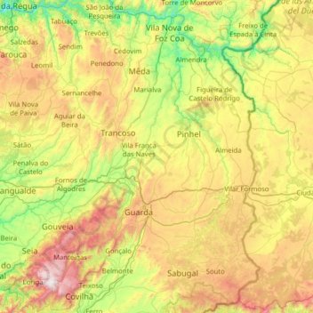
Name: Guarda topographic map, elevation, terrain.
Location: Guarda, Portugal (40.22992 -7.84923 41.17935 -6.78096)
Average elevation: 673 m
Minimum elevation: 49 m
Maximum elevation: 1,980 m
Thank you for supporting this site ❤️
Make a donation
Make a donation
Other topographic maps
Click on a map to view its topography, its elevation and its terrain.