
Thank you for supporting this site ❤️
Make a donation
Make a donation
Yser topographic map
Click on the map to display elevation.
Thank you for supporting this site ❤️
Make a donation
Make a donation
About this map
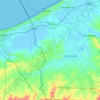
Name: Yser topographic map, elevation, terrain.
Location: Yser, Veurne, West Flanders, Flanders, Belgium (50.81315 2.32394 51.15388 2.85521)
Average elevation: 9 m
Minimum elevation: -4 m
Maximum elevation: 68 m
Thank you for supporting this site ❤️
Make a donation
Make a donation
Other topographic maps
Click on a map to view its topography, its elevation and its terrain.