
Thank you for supporting this site ❤️
Make a donation
Make a donation
Odesa Oblast topographic map
Click on the map to display elevation.
Thank you for supporting this site ❤️
Make a donation
Make a donation
About this map
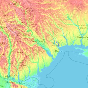
Name: Odesa Oblast topographic map, elevation, terrain.
Location: Odesa Oblast, Ukraine (45.05320 28.21383 48.23329 31.30498)
Average elevation: 86 m
Minimum elevation: -8 m
Maximum elevation: 415 m
Thank you for supporting this site ❤️
Make a donation
Make a donation
Other topographic maps
Click on a map to view its topography, its elevation and its terrain.
Kyiv
Originally on the west bank, today Kyiv is on both sides of the Dnieper, which flows southwards through the city towards the Black Sea. The older and higher western part of the city sits on numerous wooded hills (Kyiv Hills), with ravines and small rivers. Kyiv's geographical relief contributed to its…
Average elevation: 131 m
Thank you for supporting this site ❤️
Make a donation
Make a donation