Geolocate

Cantón Buenos Aires topographic map

Interactive map

Click on the map to display elevation.

Cantón Buenos Aires

Buenos Aires has an area of 2,384.22 km2 and a mean elevation of 386 metres.

Wikipedia (CC-BY-SA 3.0)

About this map

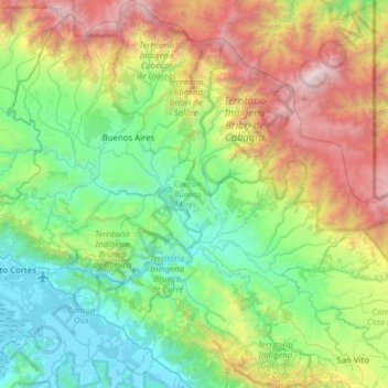
Name: Cantón Buenos Aires topographic map, elevation, terrain.

Location: Cantón Buenos Aires, Puntarenas Province, Costa Rica (8.77529 -83.56359 9.39075 -82.94757)

Average elevation: 1,003 m

Minimum elevation: 0 m

Maximum elevation: 3,529 m

Other topographic maps

Click on a map to view its topography, its elevation and its terrain.

Provincia Guanacaste

Costa Rica

Guanacaste's climate and culture are unique among Costa Rican provinces. The province experiences little rain and consistent heat from November to April, resulting in ubiquitous tropical dry forests as a natural adaption to the dry season conditions. Tourists seek out this dry heat during the North American…

Average elevation: 137 m

Cartago Province

Costa Rica

Average elevation: 1,374 m

Córdoba

Costa Rica > Cantón San José > Zapote

Average elevation: 1,165 m

Jacó

Costa Rica > Cantón Garabito

Average elevation: 138 m

Laurel

Costa Rica > Cantón Corredores > Laurel

Average elevation: 48 m

Alajuela

Costa Rica > Alajuela Province > Alajuela

The limits of the city correspond formally to the canton's first district limits, even though the city's current population and urban area stretch beyond these limits. The district of Alajuela covers an area of 8.88 km2, It lies at an elevation of 952 metres above sea level in the Central Valley, 19 kilometres…

Average elevation: 975 m

San Rafael

Costa Rica > Provincia Cartago > San Rafael

Average elevation: 1,501 m

Sánchez

Costa Rica > Provincia San José > Sánchez

Average elevation: 1,265 m

Cerro Chirripó

Costa Rica > Provincia Limón > Chirripó

Average elevation: 3,599 m

Catedral

Costa Rica > Provincia San José > Catedral

Average elevation: 1,155 m

Irazú Volcano

Costa Rica > Provincia Cartago > Santa Rosa

Average elevation: 3,114 m